Ask a Naturalist: Salem Creek Through Gateway Nature Preserve
We are very fortunate to have three different ecosystems at Gateway Nature Preserve (GNP) – the Forest, Salem Creek, and the Meadow – each offering a unique opportunity to observe different forms of plant and animal life. In this article, the focus will be on the water dynamics of Salem Creek as it winds through GNP.
From the east, Salem Creek empties out of the Salem Lake reservoir, flows through GNP and Washington Park, continues southwest as it merges with Muddy Creek, and empties into the Yadkin River near the community of Reedy Creek. The Yadkin River and its tributaries, such as Salem Creek, are part of the Yadkin-Pee Dee River Basin that flows south into the Atlantic Ocean off the coast of South Carolina. GNP and other open and natural areas along Salem Creek are important buffer zones and become floodplains during high rainfall events.

Figure 1 The Yadkin River and Salem Creek are the northernmost part of the Yadkin Pee Dee River Basin. (Source- Wikipedia Yadkin River Article)
Salem Creek takes on a meandering (or winding) path within GNP, versus upstream and downstream, where the creek has some straight paths. This natural tendency to meandering flow can be a “blessing and a curse.” As a blessing, a meandering creek slows down the movement of sediments in the inner bends. The resulting creek view is beautiful, with sandy beaches that allow easy access to the water to observe creek wildlife and wade in the coolness during the summer. As a curse, the high water after rainfall causes excessive erosion of the outer bend of the creek bank soil and exposes tree roots that may topple trees. In a natural stream, deposition of sediments in the inner bend and erosion of the outer bank maintain equilibrium. However, the urban landscape of Salem Creek watershed can escalate this process, intensifying the undercutting of the outer bends of the creek.
Gravity and geological terrain characteristics determine the creek dynamics. A creek may start out with a straight path and even banks. As time progresses, changes in terrain contour and fallen debris cause the watercourse to change as it takes on the path of least resistance. This water movement around the interference causes soil erosion, which results in a slight waviness to the water path that can grow over time, creating inner and outer stream banks. Along the inner bank, the stream current slows down due to higher sedimentation; the slower current allows the silt and rounded pebbles to settle, forming shallower water depth and “beaches” of silt buildup. At GNP, the sandy silt is actually formed from the erosion of metamorphic rocks such as quartzite and mica-schist tumbling in the creek bed, which are prevalent in this part of the Piedmont from geologic actions over the past billion years. The higher water current speed increases the water depth in the outer bank, which, over time, erodes the soil to undercut the creek bank. This can cause soil, rocks, trees, and other plant life to fall into the creek, adding interference to the water path.
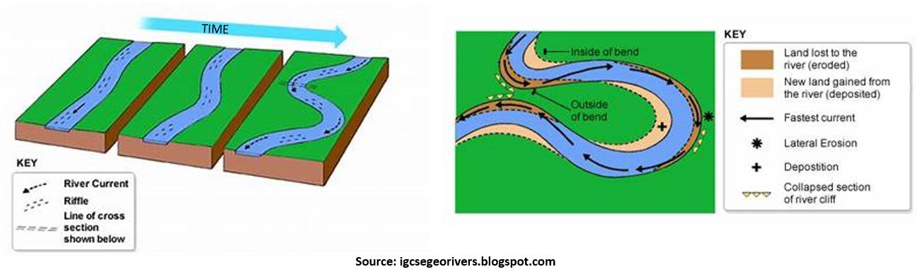
Figure 2. Nature stream processes
However, the undercutting of the outer bank adjacent to the GNP meadow is severe in part due to the urban setting of Salem Creek. Expanding paved surfaces and new residential/commercial developments alter the water flow rate, water quality and sediment load of Salem Creek. Among them, extremely high water flow during high rainfall events accelerates the undercutting of the outer banks of the creek. These and other physical and chemical effects on creek terrain, water quality and ecosystem intensified by urban infrastructures are collectively termed “urban stream syndrome”.
What can we do to minimize urbanization’s impact on local water bodies? Landscape wide restoration and ecosystem revitalization are some of the effective ways to restore natural creek functions. Some recommended methods include:
- Increase vegetated buffer zones along the creek system
- Decrease impervious surfaces in and around residential/business properties
- Opt for and expand pollinator-friendly gardens
- Cover unused areas specially along roads with native vegetation.
- Chose low-maintenance gardening methods with native vegetation
- Minimize the use of herbicides and pesticides
GNP board members and volunteers are actively working to implement many of the above strategies to reduce creek bank erosion and revitalize the creek ecosystem. Some of our past, current and future activities include:
- Regular nature education events about native and local plants and animals
- Invasive plant removal and native wildflower restoration along the creek bank and meadow. This is an ongoing process. We are in need of volunteers.
- Creek bank stabilization using native vegetation and rocks.
- Salem college student fieldwork and annual Forsyth Creek Week host site to monitor water quality and aquatic macroinvertebrate life. Refer to the GNP website for details.

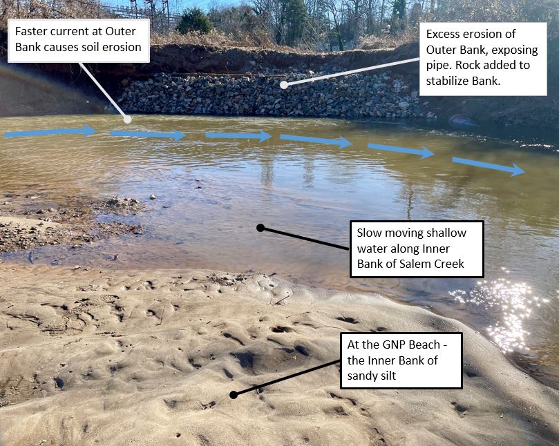
Figure 3. Salem Creek channel at GNP (left), ongoing stream bank restoration (right). (Photos by Dave Meyer)
Recommended route if you are planning to explore Salem Creek at GNP.
- Starting at the Salem Creek Greenway next to the S. Broad Street bridge, walk west towards Washington Park.
- Looking to your left, Salem Creek flows straight but changes to a winding path as you walk through GNP about 0.1 miles to the trail on the left towards the creek.
- Walk down the Beach Trail to the creek and you will be standing on the inner bank known as the GNP Beach
- Look down at the sandy silt – little bits of mica cause the sandy silt to sparkle in the sunlight. Walk the Beach and see the rounded pebbles, eroded by the water’s tumbling action and deposited during higher water levels. You may see the empty shells of Freshwater Clams, filter feeders that help keep the creek water clean.
- Look across the creek to the outer bank and see how the faster water current has eroded and undercut the bank, causing the trees to fall. An iron pipe has been exposed and covered with rock to protect this bank from further erosion.
- Unfortunately, inert trash – Styrofoam cups, soda cans, plastic bottles – can accumulate within these fallen tree branches and reminds us to respect this important ecosystem by discarding trash properly.
Sources:
- Stewart, Kevin G, and Mary-Russell Roberson. “Exploring the Geology of the Carolinas”. Russell-Robertson, pub. 2007, pg. 39.
- “Geography of Rivers.” Igcsegeorivers.blogspot.com, Accessed 30 Dec. 2023.Kominkova, Dana.
- “The Urban Stream Syndrome – a Mini-Review.” The Open Environmental & Biological Monitoring Journal, vol. 5, no. 1, 28 Dec. 2012, pp. 24–29, https://doi.org/10.2174/1875040001205010024.
- “Fluvial Features—Meandering Stream” (U.S. National Park Service).
- “Yadkin River.” Wikipedia, 28 Aug. 2023, en.wikipedia.org/wiki/Yadkin_River.
- “Meander.” Wikipedia, 10 Mar. 2021, en.wikipedia.org/wiki/Meander.